Index >> Graphic Apps >> CAD >> Plex.Earth Tools for AutoCAD
Report SpywarePlex.Earth Tools for AutoCAD 2.0
Software Description:
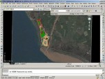
Plex.Earth Tools for AutoCAD - AutoCAD plug-in to cover large areas with color imagery from Google Earth
Using advanced mapping techniques, this AutoCAD plug-in gives you the ultimate interface to place your drawings in the real world. Plex.Earth connects AutoCAD with Google Earth and our Web Services in order to provide you a set of unique features. Enhance your design, boost your productivity and impress your customers. Plex.Earth is the "must-have" AutoCAD plug-in with many unique features, such as:
- Cover large areas: Plex.Earth will automatically create a "mosaic" of color images from Google Earth to cover large areas in AutoCAD. No more pain to do your work! It's just a matter of minutes!
- Color imagery: With Plex.Earth you will make your site plans come to life. It's true! You will never have to deliver... dead site plans to your customers again!
- Focus on your site: Finding your site in Google Earth is another trivial task for Plex.Earth.
- Geo-attach your points: You select the points in AutoCAD and Plex.Earth creates the Placemarks in Google Earth! So simple!
- Custom Transformations: Don't you have positional coordinates for your site plan? Adjust color images imported from Google Earth to your drawing by applying custom transformations.
- Plex.Earth is there for you: Processing is based on coordinates transformation for more than 2,000 coordinate systems around the world and provided through our Web Services. Fully available even for your basic AutoCAD installations.
Limitations: 7 Days Trial; 7-days Full Evaluation/50 Images Limit
Feature List:
- Cover large areas: Plex.Earth automatically imports hundreds of images from Google Earth to cover large areas. No more pain to do your work! It's just a matter of minutes
- Color imagery: With Plex.Earth you will make your site plans come to life. It's true! You will never have to deliver... dead site plans to your customers again
- Perfect Imagery Fit: Full control of how imagery will perfectly fit on your design
- Focus on your site: Finding your site in Google Earth is another trivial task for Plex.Earth
- Geo-attach your points: You select the points in AutoCAD and Plex.Earth creates the Placemarks in Google Earth! So simple
- Plex.Earth is there for you: Processing is based on coordinates transformation for more than 2,000 coordinate systems around the world and provided through our Web Services
100% Clean:
 Plex.Earth Tools for AutoCAD 2.0 is 100% clean
This download (SETUP-PLEXEARTH-ACADR17x32.zip) was tested thoroughly and was found 100% clean. Click "Report Spyware" link on the top if you found this software contains any form of malware, including but not limited to: spyware, viruses, trojans and backdoors.
Related Software:
- ABViewer 9.1 - CAD DWG DXF HPGL TIFF CGM SVG WMF STEP IGES STL SAT viewer, editor and converter
- Visual Drawing Maker 1.13 - Convert CAD files into self viewing executable (*.exe) files.
- MITCalc3D for SolidWorks 1.61 - Mechanical, Industrial and Technical Calculations for SolidWorks
- AutoQ3D CAD 5.10 - Full CAD application that let you make a lot of things in 2D & 3D
- progeCAD Professional AutoCAD Clone 2011.2.0.9 - progeCAD AutoCAD DWG Clone, 1/10th the cost, no learning curve for AutoCAD users
- DWF to DWG Converter 2007 2010 - Instantly convert DWF files to AutoCAD DWG and DXF files.
- AutoDWG Attribute Extractor 2.8 - AutoDWG Attribute Extractor, extract attribute information
- Maze Creator PRO 1.70 - Create random customized mazes with solution; add pictures, text, change shape
- ACAD DWG Viewer Pro 3 - DWGSee, a lite and fast DWG/DXF/DWF Viewer, batch print DWG/DXF/DWF files.
- VaryTable 2.1.0005 - Converts any selected text array in a CAD drawing into spread sheet cell table
top 10 most downloaded
recommended software
-
- 1AVCenter
- With 1AVCenter you can record your entire screen or part of it directly to AVI or WMV, capture screenshots in JPG, share your screen over the internet...

-
- IconEdit2
- Create and edit icon files for Windows, iPhone, iPad, Apple Watch, and Android with professional yet easy-to-use Icon Editor. IconEdit2 has full suppo...


